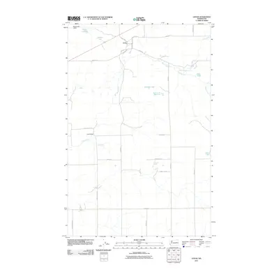
2011 Map of Govan
USGS Topo · Published 2011About this map
Govan sits at the center of this rural Lincoln County landscape, where the Channeled Scablands topography dictates the flow of water and the placement of roads. The terrain is marked by numerous small basins and drainage ways, including Rattlesnake Gulch and the seasonal paths of Wilson Creek and Goose Creek. Land use is primarily divided into large sections, as evidenced by the grid of named roads like Schoolhouse Rd N and Bodeau Rd N that connect scattered agricultural interests. Significant water features such as Hole in the Wall Lake, Nicholson Lake, and Fiddle Box Spring suggest the importance of local hydrology in this semi-arid region. Researchers will find a mix of modern infrastructure and traditional crossings, notably at Lewis Bridge which spans the local coulees, reflecting the persistent geography of the Wilbur area.
Find a feature on this map
32 named features on this map. Tap any name to fly to it.
Don’t see what you’re looking for? This feature index may not catch every label — zoom into the map to look around manually.
Map Details
Editions of this 2011 Govan Map
This is the sole edition of this map. No revisions or reprints were ever made.
Other maps of this area

1948 · Grand Coulee Dam
USGS Topo · 1:62,500

1948 · Wilbur
USGS Topo · 1:62,500

1950 · Wilbur
USGS Topo · 1:62,500

1950 · Grand Coulee Dam
USGS Topo · 1:62,500

1953 · Ritzville
USGS Topo · 1:250,000

1959 · Ritzville
USGS Topo · 1:250,000

1965 · Ritzville
USGS Topo · 1:250,000

1969 · Almira
USGS Topo · 1:24,000

1969 · Almira SE
USGS Topo · 1:24,000
1969 · Almira SW
USGS Topo · 1:24,000