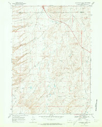
1968 Map of Government Creek
USGS Topo · Published 1973About this map
The Smoky Gap Oil Field anchors the landscape of this Wyoming quadrangle, where the border of Johnson County and Natrona County cuts through the northern terrain. This is a region defined by energy extraction and industrial resource management, evidenced by the intricate network of pipelines crossing the high country and several claypits located near Hay Draw. The topographic data, field-checked in 1968, reveals a rugged drainage system characterized by deep incisions like Eagle Canyon, Toy Canyon, and Long Canyon. Water management in this arid environment is highlighted by Twin Reservoir and a Gaging Station on Dugout Creek. From the heights of Tisdale Mountain to the southern reaches of Government Creek, the map provides a look at the infrastructure required to support mid-century oil and mineral operations in the American West.
Find a feature on this map
26 named features on this map. Tap any name to fly to it.
Don’t see what you’re looking for? This feature index may not catch every label — zoom into the map to look around manually.
Map Details
Editions of this 1968 Government Creek Map
2 editions found
Other maps of this area

1955 · Arminto
USGS Topo · 1:250,000

1958 · Arminto
USGS Topo · 1:250,000

1961 · Dugout Ranch
USGS Topo · 1:24,000

1961 · Dead Woman Crossing
USGS Topo · 1:24,000

1961 · Wall Creek
USGS Topo · 1:24,000

1962 · Arminto
USGS Topo · 1:250,000

1968 · Big Gulch
USGS Topo · 1:24,000

1968 · Midwest
USGS Topo · 1:24,000

1968 · Salt Creek
USGS Topo · 1:24,000

1968 · Camel Hump Reservoir
USGS Topo · 1:24,000