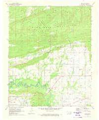
1971 Map of Gowen
USGS Topo · Published 1973About this map
The Sans Bois Mountains dominate the northern landscape of this region, giving way to the industrial and agricultural valley of Gaines Creek to the south. In the early 1970s, this area reflects a complex transition between natural terrain and heavy extraction, characterized by numerous Gas Wells and visible Strip Mines near the settlement of Gowen. The expansion of Eufaula Lake reaches into the western edge of the map, altering the traditional drainage patterns of Beaver Creek and Boiling Springs Creek. Transport and infrastructure are central to the local economy, evidenced by the Chicago Rock Island and Pacific railroad line and the Wilburton Airport. Smaller communities like Bowers, Patterson, and Chilli serve as residential hubs near family landmarks such as the Gowen Cem and Bowers Ch.
Find a feature on this map
25 named features on this map. Tap any name to fly to it.
Don’t see what you’re looking for? This feature index may not catch every label — zoom into the map to look around manually.
Map Details
Editions of this 1971 Gowen Map
2 editions found
Other maps of this area

1898 · McAlester
USGS Topo · 1:125,000

1900 · Sansbois
USGS Topo · 1:125,000

1900 · Canadian
USGS Topo · 1:125,000

1901 · Tuskahoma
USGS Topo · 1:125,000

1908 · Tuskahoma
USGS Topo · 1:125,000

1909 · Mc Alester
USGS Topo · 1:125,000

1909 · Tuskahoma
USGS Topo · 1:125,000

1909 · Sans Bois
USGS Topo · 1:125,000

1911 · Sansbois
USGS Topo · 1:125,000

1946 · Fort Smith
USGS Topo · 1:250,000