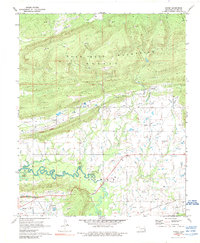
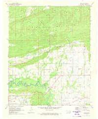
1971 Map of Gowen
USGS Topo · Published 1989About this map
The Sans Bois Mountains dominate the northern half of this landscape, giving way to the industrial and agricultural valley of Gaines Creek below. In the early 1970s, this area of Latimer County remained a hub for natural resource extraction, defined by numerous Gas Wells and visible Strip Mines south of the mountain ridge. The settlement of Gowen is a focal point for local history, featuring the Gowen Cem and connections to the Chicago Rock Island and Pacific railroad.
Find a feature on this map
24 named features on this map. Tap any name to fly to it.
Don’t see what you’re looking for? This feature index may not catch every label — zoom into the map to look around manually.
Map Details
Editions of this 1971 Gowen Map
2 editions found
Other maps of this area

1898 · McAlester
USGS Topo · 1:125,000

1900 · Sansbois
USGS Topo · 1:125,000

1900 · Canadian
USGS Topo · 1:125,000

1901 · Tuskahoma
USGS Topo · 1:125,000

1908 · Tuskahoma
USGS Topo · 1:125,000

1909 · Mc Alester
USGS Topo · 1:125,000

1909 · Tuskahoma
USGS Topo · 1:125,000

1909 · Sans Bois
USGS Topo · 1:125,000

1911 · Sansbois
USGS Topo · 1:125,000

1946 · Fort Smith
USGS Topo · 1:250,000