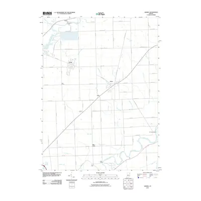
2010 Map of Grabill
USGS Topo · Published 2010About this map
The Saint Joseph River and Maumee River systems anchor this eastern Indiana landscape, where agricultural drainage is meticulously managed through an extensive network of man-made waterways. Significant labels like Swartz-Carnahan Ditch, Boger Ditch, and Smith-Fry Ditch illustrate the complex hydrography required to sustain the region's fertile farmland. Centered on the town of Grabill, the map documents a mix of rural crossroads and established settlements including Harlan and Milan Center. For those researching local family history, the map provides precise locations for the Yaggy Cemetery and Barnett Cemetery, while landmarks such as the Hurshtown Bridge and Airpark Field offer points of reference for the early 21st-century infrastructure. The presence of the Cedarville Reservoir in the northwest corner highlights the importance of water management in this well-settled portion of Allen County.
Find a feature on this map
72 named features on this map. Tap any name to fly to it.
Don’t see what you’re looking for? This feature index may not catch every label — zoom into the map to look around manually.
Map Details
Editions of this 2010 Grabill Map
This is the sole edition of this map. No revisions or reprints were ever made.
Other maps of this area

1953 · Fort Wayne
USGS Topo · 1:250,000

1956 · Fort Wayne
USGS Topo · 1:250,000

1956 · Fort Wayne East
USGS Topo · 1:24,000

1956 · Cedarville
USGS Topo · 1:24,000

1957 · Auburn
USGS Topo · 1:24,000

1957 · Maples
USGS Topo · 1:24,000

1958 · Hicksville
USGS Topo · 1:24,000

1958 · Grabill
USGS Topo · 1:24,000

1958 · Woodburn North
USGS Topo · 1:24,000
1958 · Saint Joe
USGS Topo · 1:24,000