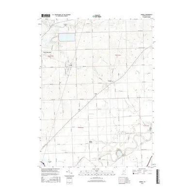
2016 Map of Grabill
USGS Topo · Published 2016About this map
The Saint Joseph River and the Maumee River define the hydraulic character of this northeastern Indiana landscape, where an intricate network of drainage ditches supports the surrounding agricultural fields. Near the historic channel of the Wabash and Erie Canal, the terrain transitions from the developed centers of Leo-Cedarville and Grabill to the smaller crossroads of Cuba and Milan Center. Local history is preserved in sites like Yaggy Cem and Barnett Cem, while the Hurstown Reservoir serves as a prominent modern landmark in the northwest. Several historic spans, including the Hurstown Bridge and Platter Bridge, facilitate movement across the river systems, illustrating the enduring transport patterns of Allen County. Small-scale aviation is represented by Turkey Run Airport, situated near the southern edge of the quadrangle.
Find a feature on this map
95 named features on this map. Tap any name to fly to it.
Don’t see what you’re looking for? This feature index may not catch every label — zoom into the map to look around manually.
Map Details
Editions of this 2016 Grabill Map
This is the sole edition of this map. No revisions or reprints were ever made.
Other maps of this area

1953 · Fort Wayne
USGS Topo · 1:250,000

1956 · Fort Wayne
USGS Topo · 1:250,000

1956 · Fort Wayne East
USGS Topo · 1:24,000

1956 · Cedarville
USGS Topo · 1:24,000

1957 · Auburn
USGS Topo · 1:24,000

1957 · Maples
USGS Topo · 1:24,000

1958 · Hicksville
USGS Topo · 1:24,000

1958 · Grabill
USGS Topo · 1:24,000

1958 · Woodburn North
USGS Topo · 1:24,000
1958 · Saint Joe
USGS Topo · 1:24,000