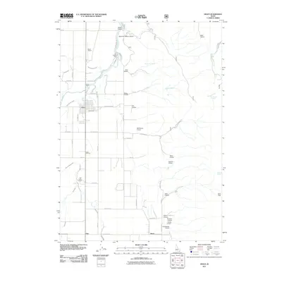
2011 Map of Grace
USGS Topo · Published 2011About this map
Grace and the smaller settlement of Niter anchor this Idaho landscape, where the engineering of the Bear River defines the local economy. The river's path is marked by significant infrastructure including the Grace Dam and the Last Chance Dam, which feed an intricate network of irrigation systems such as the Last Chance Canal, Tanner Canal, and North Extension Canal. These waterways underscore the area's agricultural reliance on diverted water as it flows through the valley.
Find a feature on this map
60 named features on this map. Tap any name to fly to it.
Don’t see what you’re looking for? This feature index may not catch every label — zoom into the map to look around manually.
Map Details
Editions of this 2011 Grace Map
This is the sole edition of this map. No revisions or reprints were ever made.
Other maps of this area

1915 · Preston
USGS Topo · 1:96,000

1918 · Preston
USGS Topo · 1:125,000

1948 · Bancroft
USGS Topo · 1:62,500

1948 · Soda Springs
USGS Topo · 1:62,500

1949 · Bancroft
USGS Topo · 1:62,500

1949 · Soda Springs
USGS Topo · 1:62,500

1955 · Preston
USGS Topo · 1:250,000

1958 · Preston
USGS Topo · 1:250,000

1962 · Preston
USGS Topo · 1:250,000
1969 · North Canyon
USGS Topo · 1:24,000