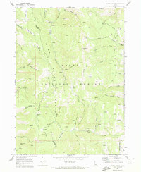
1969 Map of North Canyon
USGS Topo · Published 1973About this map
Sherman Peak towers over a landscape defined by deep drainages and spring-fed basins within the Cache National Forest. This 1969 survey captures the rugged backcountry of southeastern Idaho where the borders of Bear Lake, Caribou, and Franklin counties converge. The drainage system is complex, featuring Eightmile Creek and the numerous forks of Skinner Creek, all separated by high ridges like Red Pine Ridge. Local landmarks such as Moonlight Meadow and Loa Lake suggest the seasonal rhythms of high-elevation grazing and recreation that define the region. The map documents an intricate network of jeep trails and pack trails winding through Cheatbeck Canyon and Ant Canyon, providing evidence of historical access routes for forestry and early exploration. Numerous named water sources, including Tie Camp Spring and Humberg Spring, are precisely mapped, serving as vital points of interest for historical land use studies.
Find a feature on this map
40 named features on this map. Tap any name to fly to it.
Don’t see what you’re looking for? This feature index may not catch every label — zoom into the map to look around manually.
Map Details
Editions of this 1969 North Canyon Map
2 editions found
Other maps of this area

1909 · Montpelier
USGS Topo · 1:125,000

1911 · Montpelier
USGS Topo · 1:125,000

1911 · Slug Creek
USGS Topo · 1:62,500

1915 · Preston
USGS Topo · 1:96,000

1918 · Preston
USGS Topo · 1:125,000

1948 · Soda Springs
USGS Topo · 1:62,500

1949 · Soda Springs
USGS Topo · 1:62,500

1955 · Preston
USGS Topo · 1:250,000

1958 · Preston
USGS Topo · 1:250,000

1962 · Preston
USGS Topo · 1:250,000