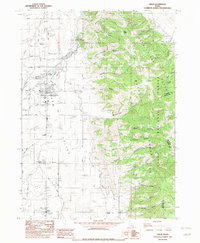
1982 Map of Grace
USGS Topo · Published 1982About this map
Gem Valley is defined by its complex irrigation network and the winding course of the Bear River as it passes through eastern Idaho. The town of Grace serves as the central hub of this agricultural landscape, showing a dense grid of streets, multiple grain tanks, and a High Sch. This 1982 map details the critical infrastructure of the era, including the Grace Dam and a series of canals and laterals that support the surrounding fields. To the south, the smaller settlement of Niter is marked by grain tanks and local roads, illustrating the region's reliance on agriculture and rail transport.
Find a feature on this map
33 named features on this map. Tap any name to fly to it.
Don’t see what you’re looking for? This feature index may not catch every label — zoom into the map to look around manually.
Map Details
Editions of this 1982 Grace Map
This is the sole edition of this map. No revisions or reprints were ever made.
Other maps of this area

1915 · Preston
USGS Topo · 1:96,000

1918 · Preston
USGS Topo · 1:125,000

1948 · Bancroft
USGS Topo · 1:62,500

1948 · Soda Springs
USGS Topo · 1:62,500

1949 · Bancroft
USGS Topo · 1:62,500

1949 · Soda Springs
USGS Topo · 1:62,500

1955 · Preston
USGS Topo · 1:250,000

1958 · Preston
USGS Topo · 1:250,000

1962 · Preston
USGS Topo · 1:250,000
1969 · North Canyon
USGS Topo · 1:24,000