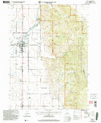
2005 Map of Grace
USGS Topo · Published 2007About this map
Gem Valley serves as a productive agricultural basin in this 2005 revision, where the Bear River is harnessed for irrigation and power. The town of Grace stands as the primary hub, characterized by its grid of streets and the High Sch, while the settlement of Niter lies to the south. Water management is the defining landscape feature, evidenced by the Grace Dam, Last Chance Dam, and the extensive Last Chance Canal system that feeds the valley's farms. To the east, the terrain rises into the Wasatch Range and Bear River Range, part of the Caribou National Forest. Geological curiosities like the Ice Cave and Ice Cave Knoll punctuate the valley floor, providing a stark contrast to the surrounding canyon-cleft mountains such as Nelson Canyon and Burton Canyon.
Find a feature on this map
52 named features on this map. Tap any name to fly to it.
Don’t see what you’re looking for? This feature index may not catch every label — zoom into the map to look around manually.
Map Details
Editions of this 2005 Grace Map
This is the sole edition of this map. No revisions or reprints were ever made.
Other maps of this area

1915 · Preston
USGS Topo · 1:96,000

1918 · Preston
USGS Topo · 1:125,000

1948 · Bancroft
USGS Topo · 1:62,500

1948 · Soda Springs
USGS Topo · 1:62,500

1949 · Bancroft
USGS Topo · 1:62,500

1949 · Soda Springs
USGS Topo · 1:62,500

1955 · Preston
USGS Topo · 1:250,000

1958 · Preston
USGS Topo · 1:250,000

1962 · Preston
USGS Topo · 1:250,000
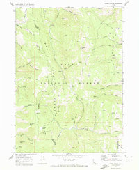
1969 · North Canyon
USGS Topo · 1:24,000