
1958 Map of Gracelock NW
USGS Topo · Published 1960About this map
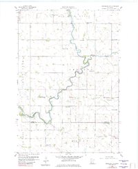
The Chippewa River meanders through the heart of the Minnesota prairie in this late-1950s survey, marking a period of rural density before widespread farm consolidation. This area, spanning the townships of Six Mile Grove, Swenoda, Big Bend, and Mandt, reveals an incredibly active network of local education, with nearly a dozen small schoolhouses still identified by number across the landscape. The confluence of Shakopee Creek and the river defines the central terrain, while the Swift Co Chippewa Co line cuts through the southern reaches. Local landmarks such as Trinity Ch and the Big Bend Cem provide valuable anchor points for genealogical research, while several Gravel Pits in the southeast corner indicate the local extraction industry of the era. The detailed topography illustrates the numerous small depressions and drainage patterns characteristic of this glaciated agricultural region.
Find a feature on this map
18 named features on this map. Tap any name to fly to it.
Don’t see what you’re looking for? This feature index may not catch every label — zoom into the map to look around manually.
Map Details
Editions of this 1958 Gracelock NW Map
2 editions found
Other maps of this area

1953 · Saint Cloud
USGS Topo · 1:250,000

1957 · Saint Cloud
USGS Topo · 1:250,000

1958 · Saint Cloud
USGS Topo · 1:250,000

1958 · Gracelock NE
USGS Topo · 1:24,000

1958 · Big Bend City
USGS Topo · 1:24,000

1958 · Watson
USGS Topo · 1:24,000

1958 · Gracelock
USGS Topo · 1:24,000

1958 · Gracelock SW
USGS Topo · 1:24,000

1968 · Danvers
USGS Topo · 1:24,000

1968 · Benson
USGS Topo · 1:24,000