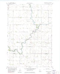
1958 Map of Gracelock NW
USGS Topo · Published 1982About this map
The Chippewa River winds through this rural landscape in western Minnesota, defining the border between Swift Co and Chippewa Co at its southern end. This 1950s survey captures a highly organized agrarian landscape divided into townships including Six Mile Grove, Swenoda, and Mandt. The density of rural infrastructure from this era is notable, with numerous small district schools such as School No 2185 and School No 2201 scattered across the grid to serve the surrounding farmsteads.
Find a feature on this map
20 named features on this map. Tap any name to fly to it.
Don’t see what you’re looking for? This feature index may not catch every label — zoom into the map to look around manually.
Map Details
Editions of this 1958 Gracelock NW Map
2 editions found
Other maps of this area

1953 · Saint Cloud
USGS Topo · 1:250,000

1957 · Saint Cloud
USGS Topo · 1:250,000

1958 · Saint Cloud
USGS Topo · 1:250,000

1958 · Gracelock NE
USGS Topo · 1:24,000

1958 · Big Bend City
USGS Topo · 1:24,000

1958 · Watson
USGS Topo · 1:24,000

1958 · Gracelock NW
USGS Topo · 1:24,000

1958 · Gracelock
USGS Topo · 1:24,000

1958 · Gracelock SW
USGS Topo · 1:24,000

1968 · Danvers
USGS Topo · 1:24,000