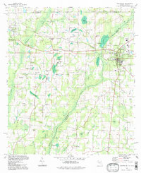
1994 Map of Graceville
USGS Topo · Published 1998About this map
Graceville serves as the primary hub on this Florida-Alabama border survey, where the L & N RR corridor intersects with a landscape of agricultural hills and significant wetlands. The terrain is defined by a series of family-named elevations such as Brown Hill and Murphy Hill, giving way to the intricate drainage system of Holmes Creek and numerous bayous including Buzzard Bay and Underwood Bay. This 1990s record captures the region's rural character through its network of small crossings and community landmarks, such as Underwood Crossing and Tendil Crossing. Local heritage is anchored by dispersed religious and educational sites like Liberty Hill Ch, Damascus Ch, and the Poplar Springs Sch. The presence of Collins Mill near the town center reflects a long-standing reliance on local watercourses and timber, while the surrounding marshlands like Richardson Bay remain largely untouched by heavy development.
Find a feature on this map
67 named features on this map. Tap any name to fly to it.
Don’t see what you’re looking for? This feature index may not catch every label — zoom into the map to look around manually.
Map Details
Editions of this 1994 Graceville Map
This is the sole edition of this map. No revisions or reprints were ever made.
Other maps of this area

1942 · Enterprise
USGS Topo · 1:125,000

1950 · Chipley
USGS Topo · 1:24,000

1950 · Esto
USGS Topo · 1:24,000

1951 · Graceville
USGS Topo · 1:24,000

1951 · Esto
USGS Topo · 1:24,000

1951 · Chipley
USGS Topo · 1:24,000

1951 · Bonifay
USGS Topo · 1:24,000

1952 · Campbellton
USGS Topo · 1:24,000

1952 · Cottondale West
USGS Topo · 1:24,000

1953 · Dothan
USGS Topo · 1:250,000