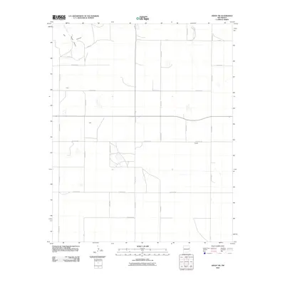
2010 Map of Grady SW
USGS Topo · Published 2010About this map
The Caprock defines the northwestern corner of this territory, where the high plains drop away into the drainage of Puerto Canyon. Below this dramatic geological break, Puerto Creek winds through a landscape marked by a rigid grid of rural roads that cross the border between Quay and Curry counties. This 2010 survey illustrates a sparsely populated agricultural region, punctuated only by small named localities such as Owen, Best, and Hatfield. The map reveals the transition between the Llano Estacado plateau and the lower-lying breaks, showing how early 21st-century infrastructure like Quay Road AB and Curry Road Y follows the sectional lines established a century prior. The sparse distribution of settlements and the prominence of local road designations suggest an area dominated by ranching and large-scale farming where proximity to the caprock edge dictates the local topography.
Find a feature on this map
27 named features on this map. Tap any name to fly to it.
Don’t see what you’re looking for? This feature index may not catch every label — zoom into the map to look around manually.
Map Details
Editions of this 2010 Grady SW Map
This is the sole edition of this map. No revisions or reprints were ever made.
Other maps of this area

1954 · Clovis
USGS Topo · 1:250,000

1957 · Hammond Ranch
USGS Topo · 1:62,500

1958 · Clovis
USGS Topo · 1:250,000
1971 · Apache Canyon
USGS Topo · 1:24,000

1971 · Wheatland
USGS Topo · 1:24,000
1971 · Norton
USGS Topo · 1:24,000

1971 · Grady
USGS Topo · 1:24,000

1971 · Grady SW
USGS Topo · 1:24,000

1971 · Forrest
USGS Topo · 1:24,000
1973 · Field
USGS Topo · 1:24,000