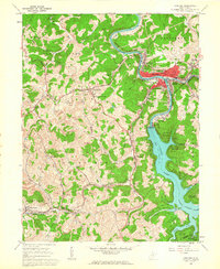
1960 Map of Grafton
USGS Topo · Published 1963About this map
The Baltimore and Ohio railroad corridor anchors this mid-century portrait of Taylor County, connecting the bustling industrial hub of Grafton to outlying mining and agricultural communities. The terrain is defined by the winding course of the Tygart River and the expansive Tygart Lake, where the newly established Tygart Lake State Park begins to shape the local landscape. Settlement patterns follow the narrow valley floors and ridgelines, from the historical center at Pruntytown—site of the W Va Industrial School for Boys—to smaller railroad and coal hamlets like Simpson and Wendel. Extensive Strip Mine symbols scattered across the western hills reflect the era's intensive resource extraction. Genealogists will find significant detail in the numerous family and community landmarks, including the National Cem and Linn Chapel, which serve as quiet markers of the region's long-standing social fabric.
Find a feature on this map
60 named features on this map. Tap any name to fly to it.
Don’t see what you’re looking for? This feature index may not catch every label — zoom into the map to look around manually.
Map Details
Editions of this 1960 Grafton Map
3 editions found
Other maps of this area

1886 · St. George
USGS Topo · 1:125,000

1891 · St. George
USGS Topo · 1:125,000

1902 · Fairmont
USGS Topo · 1:62,500

1904 · Philippi
USGS Topo · 1:62,500

1907 · Thornton
USGS Topo · 1:62,500

1907 · Belington
USGS Topo · 1:62,500

1923 · Fairmont
USGS Topo · 1:62,500

1925 · Philippi
USGS Topo · 1:62,500

1926 · Fairmont
USGS Topo · 1:62,500

1926 · Thornton
USGS Topo · 1:62,500