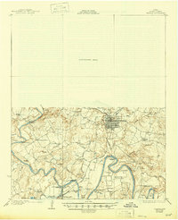
1927 Map of Graham
USGS Topo · Published 1946About this map
Graham stands as the primary hub of this Young County landscape, situated just north of the dramatic meanders of the Brazos River. The map documents a rural society deeply connected to the river's path, where the Salt Fork Brazos River and Clear Fork Brazos River converge near South Bend. This mid-1920s survey reveals a landscape of dispersed agricultural communities, each centered on a local schoolhouse such as Tonk Valley School, Salem School, or Brier Branch School.
Find a feature on this map
48 named features on this map. Tap any name to fly to it.
Don’t see what you’re looking for? This feature index may not catch every label — zoom into the map to look around manually.
Map Details
Editions of this 1927 Graham Map
2 editions found
Other maps of this area

1890 · Breckenridge
USGS Topo · 1:125,000

1891 · Palo Pinto
USGS Topo · 1:125,000

1918 · Palo Pinto
USGS Topo · 1:125,000

1924 · Breckenridge 1-a
USGS Topo · 1:48,000

1924 · Palo Pinto 2-b
USGS Topo · 1:48,000

1924 · Graham 4-d
USGS Topo · 1:48,000

1925 · Graham 4-c
USGS Topo · 1:48,000

1925 · Breckenridge 1-b
USGS Topo · 1:48,000

1927 · Graham
USGS Topo · 1:62,500

1927 · Pickwick
USGS Topo · 1:62,500