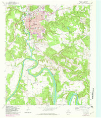
1967 Map of Graham
USGS Topo · Published 1982About this map
Graham anchors this landscape in the late 1960s, showing a well-established city grid that includes Shawnee Sch and a large central Hospital. To the south, the dramatic meandering of the Brazos River creates distinct landforms like Gooseneck Bend and Herron Bend, as the river flows toward the upper reaches of Possum Kingdom Lake. This survey documents a transition in local infrastructure, noting a prominent Railroad Grade running southwest alongside older landmarks such as the Old Cangyville Crossing. Rural life is marked by several family and community burial grounds, including Oak Grove Cem and Farmer Cem, while the surrounding terrain is defined by Haynes Mountain and the double peaks of Twin Mts. The presence of many oil and gas wells throughout the hills suggests the area's continued reliance on energy production during this era.
Find a feature on this map
41 named features on this map. Tap any name to fly to it.
Don’t see what you’re looking for? This feature index may not catch every label — zoom into the map to look around manually.
Map Details
Editions of this 1967 Graham Map
2 editions found
Other maps of this area

1890 · Breckenridge
USGS Topo · 1:125,000

1891 · Palo Pinto
USGS Topo · 1:125,000

1918 · Palo Pinto
USGS Topo · 1:125,000

1924 · Breckenridge 1-a
USGS Topo · 1:48,000

1924 · Palo Pinto 2-b
USGS Topo · 1:48,000

1924 · Graham 4-d
USGS Topo · 1:48,000

1925 · Graham 4-c
USGS Topo · 1:48,000

1925 · Breckenridge 1-b
USGS Topo · 1:48,000

1927 · Graham
USGS Topo · 1:62,500

1927 · Pickwick
USGS Topo · 1:62,500