
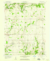
1958 Map of Grammer
USGS Topo · Published 1959About this map
Chicago Milwaukee St Paul and Pacific tracks across the rural landscape, connecting the small railway settlements of Grammer and Sardinia. This late-1950s survey reflects a quintessential Midwestern agricultural economy, where the rail line serves as a central artery through the townships of Rock Creek and Sand Creek. Scattered rural communities like Alert, Burnsville, and Waynesburg are hubs for the surrounding farmsteads, while numerous family and community landmarks such as Mt Olivet Cem and Parkison Cem provide significant genealogical value. The topography is defined by the drainage patterns of Clifty Creek and Bear Creek, which carve gentle valleys through the fertile plains. The inclusion of localized details like Township Sch and several Gas Wells suggests a landscape transitioning between traditional agrarian life and early modern resource extraction.
Find a feature on this map
36 named features on this map. Tap any name to fly to it.
Don’t see what you’re looking for? This feature index may not catch every label — zoom into the map to look around manually.
Map Details
Editions of this 1958 Grammer Map
4 editions found
Other maps of this area

1942 · Columbus
USGS Topo · 1:125,000

1947 · Hope
USGS Topo · 1:24,000

1948 · Hope
USGS Topo · 1:24,000

1950 · Edinburg
USGS Topo · 1:62,500

1953 · Cincinnati
USGS Topo · 1:250,000

1957 · Cincinnati
USGS Topo · 1:250,000

1957 · Butlerville
USGS Topo · 1:24,000

1957 · Azalia
USGS Topo · 1:24,000

1957 · North Vernon
USGS Topo · 1:24,000

1958 · Westport
USGS Topo · 1:24,000