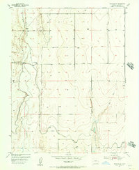
1955 Map of Granada NW
USGS Topo · Published 1956About this map
Big Sandy Creek and the Comanche Canal dominate this mid-century view of the Prowers County high plains. This 1955 study reveals a landscape defined by water management and rural education, where the Amity Canal works alongside an extensive Levee system to control the erratic flow of the local drainages. The map records specific rural infrastructure such as a Siphon, a Flume, and a Road on Levee, indicating a highly engineered agricultural environment. Notable local landmarks for genealogical research include the Sand Creek Sch and the Goodale Sch, providing evidence of the community's distribution before further consolidation. Elevated terrain features like Tenmile Point and Stony Point provide geographic markers above the creek beds, while a small Airstrip in the northwest corner highlights early private aviation in the region.
Find a feature on this map
18 named features on this map. Tap any name to fly to it.
Don’t see what you’re looking for? This feature index may not catch every label — zoom into the map to look around manually.
Map Details
Editions of this 1955 Granada NW Map
2 editions found
Other maps of this area

1890 · Granada
USGS Topo · 1:125,000

1892 · Lamar
USGS Topo · 1:125,000

1892 · Granada
USGS Topo · 1:125,000

1894 · Granada
USGS Topo · 1:125,000

1952 · Carlton
USGS Topo · 1:24,000

1953 · Granada
USGS Topo · 1:24,000

1953 · Lamar East
USGS Topo · 1:24,000

1954 · Lamar
USGS Topo · 1:250,000

1955 · Granada NW
USGS Topo · 1:24,000

1955 · Granada NE
USGS Topo · 1:24,000