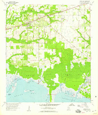
1958 Map of Grand Bay
USGS Topo · Published 1959About this map
Grand Bay and its surrounding coastal lowlands are defined by a complex network of tidal inlets and marshes along the Alabama Gulf Coast. In the late 1950s, the Louisville and Nashville railroad served as the primary terrestrial artery, connecting the settlement of Fernland to the larger regional trade network. The landscape transitions from agricultural and wooded uplands near the Grand Bay Cem to the expansive Grand Bay Swamp, a labyrinth of watercourses including Bayou Caddy and Bull Bay Bayou. Along the southern shoreline, the map details the maritime environment of Portersville Bay and Sandy Bay, where Marsh Island sits offshore. Aviation infrastructure is noted at the St Elmo Landing Field, while the presence of several Sandpits indicates local extractive industry during this mid-century period.
Find a feature on this map
30 named features on this map. Tap any name to fly to it.
Don’t see what you’re looking for? This feature index may not catch every label — zoom into the map to look around manually.
Map Details
Editions of this 1958 Grand Bay Map
3 editions found
Other maps of this area

1921 · Grand Bay
USGS Topo · 1:62,500

1921 · Delchamps
USGS Topo · 1:62,500

1922 · Mobile
USGS Topo · 1:62,500

1940 · Mobile
USGS Topo · 1:62,500

1941 · Cedar Point
USGS Topo · 1:62,500

1941 · Hurley
USGS Topo · 1:62,500

1942 · Theodore
USGS Topo · 1:31,680

1943 · Cedar Point
USGS Topo · 1:62,500

1943 · Theodore
USGS Topo · 1:31,680

1943 · Grand Bay
USGS Topo · 1:62,500