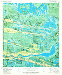
1980 Map of Grand Chenier
USGS Topo · Published 1980About this map
Grand Chenier Ridge and the Mermentau River dominate this coastal landscape, illustrating the unique geological formation of cheniers—elevated sandy ridges topped with oaks that sit amidst the marshlands of Cameron Parish. This 1980 orthophotomap, based on late-1970s aerial photography, reveals the established settlement of Grand Chenier clustered along the high ground of the ridge. The map is a vital record for genealogists, detailing numerous family and church burial sites including Boudoin Cem, Shady Oaks Cem, and Our Lady of the Marsh Cem. The drainage patterns and industrial activity of the era are evident through the network of Canal systems, oil wells, and the Humble pipeline. From the expansive Upper Mud Lake to smaller water bodies like Marseillaise Bayou, the map tracks how the community adapted to this amphibious environment.
Find a feature on this map
36 named features on this map. Tap any name to fly to it.
Don’t see what you’re looking for? This feature index may not catch every label — zoom into the map to look around manually.
Map Details
Editions of this 1980 Grand Chenier Map
2 editions found
Other maps of this area

1934 · Catfish Lake
USGS Topo · 1:24,000

1934 · Lake Misere
USGS Topo · 1:24,000

1934 · Boudreaux Lake
USGS Topo · 1:24,000

1934 · Latania Lake
USGS Topo · 1:24,000

1935 · Lake Misere
USGS Topo · 1:31,680

1935 · Catfish Lake
USGS Topo · 1:31,680

1935 · Latania Lake
USGS Topo · 1:31,680

1935 · Boudreaux Lake
USGS Topo · 1:31,680

1935 · Bay Labauve
USGS Topo · 1:31,680

1935 · Grand Chenier
USGS Topo · 1:31,680