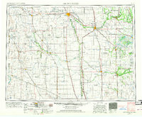
1952 Map of Grand Forks
USGS Topo · Published 1973About this map
The Red River of the North serves as the central artery for this mid-century portrait of the fertile Red River Valley, marking the border between North Dakota and Minnesota. The agricultural landscape is meticulously organized by the township and range system, punctuated by small grain-elevator towns like Grandin, Argusville, and Felton. Infrastructure of the Cold War era is evident at the Grand Forks AFB, while regional conservation is highlighted by the Kellys Slough National Wildlife Refuge and the Red River Game Refuge (State). Social life of the period is anchored by rural institutions such as the Pleasant View Church and Immanuel Lutheran Church. The eastern portion of the map transitions into the wooded boundaries of the White Earth Indian Reservation, showing a distinct shift in land use from the intensive cultivation of the valley floor.
Find a feature on this map
183 named features on this map. Tap any name to fly to it.
Don’t see what you’re looking for? This feature index may not catch every label — zoom into the map to look around manually.
Map Details
Editions of this 1952 Grand Forks Map
3 editions found

Other maps of this area

1895 · Fargo
USGS Topo · 1:125,000

1895 · Casselton
USGS Topo · 1:125,000

1897 · Fargo
USGS Topo · 1:125,000

1897 · Tower
USGS Topo · 1:125,000

1897 · Eckelson
USGS Topo · 1:125,000

1897 · Casselton
USGS Topo · 1:125,000

1918 · Kelso
USGS Topo · 1:62,500

1918 · Angus
USGS Topo · 1:62,500

1918 · Hendrum
USGS Topo · 1:62,500

1918 · Twin Valley
USGS Topo · 1:62,500