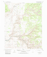
1963 Map of Grand Gulch
USGS Topo · Published 1984About this map
Cliff Dwellings and prehistoric petroglyphs are scattered across this 1963 survey of the Utah canyonlands, concentrated particularly within the deep reaches of Grand Gulch and its tributaries like Step Canyon and Bullet Canyon. The map documents a landscape defined by dramatic topographical shifts from the Cedar Mesa plateau down to the San Juan River and the rising waters of Lake Powell within the Glen Canyon National Recreation Area.
Find a feature on this map
38 named features on this map. Tap any name to fly to it.
Don’t see what you’re looking for? This feature index may not catch every label — zoom into the map to look around manually.
Map Details
Editions of this 1963 Grand Gulch Map
4 editions found
Other maps of this area

1886 · Henry Mountains
USGS Topo · 1:250,000

1886 · Abajo
USGS Topo · 1:250,000

1892 · Abajo
USGS Topo · 1:250,000

1892 · Henry Mountains
USGS Topo · 1:250,000

1893 · Abajo
USGS Topo · 1:250,000

1935 · Elk Ridge
USGS Topo · 1:96,000

1940 · Elk Ridge
USGS Topo · 1:125,000

1952 · Mancos Mesa
USGS Topo · 1:62,500

1952 · Natural Bridges
USGS Topo · 1:62,500

1952 · Oljeto
USGS Topo · 1:62,500