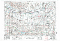
1955 Map of Grand Island
USGS Topo · Published 1980About this map
Grand Island and the broad valley of the Platte River serve as the focal point for this mid-century look at central Nebraska and northern Kansas. The landscape is defined by the heavy infrastructure of the era, from the sprawling Cornhusker Army Ammunition Plant to the dense network of the Union Pacific RR and Burlington Northern RR. These rail lines follow the historic path of the Platte, connecting grain-handling settlements like Lexington, Kearney, and Wood River.
Find a feature on this map
134 named features on this map. Tap any name to fly to it.
Don’t see what you’re looking for? This feature index may not catch every label — zoom into the map to look around manually.
Map Details
Editions of this 1955 Grand Island Map
3 editions found

Other maps of this area

1892 · Concordia
USGS Topo · 1:125,000

1892 · Grand Island
USGS Topo · 1:62,500

1893 · Smith Center
USGS Topo · 1:125,000

1893 · Norton
USGS Topo · 1:125,000

1893 · Phillipsburg
USGS Topo · 1:125,000

1894 · Mankato
USGS Topo · 1:125,000

1894 · Kenesaw
USGS Topo · 1:62,500

1894 · Kearney
USGS Topo · 1:62,500

1894 · Minden
USGS Topo · 1:62,500

1895 · Grand Island
USGS Topo · 1:62,500