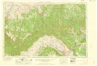
1960 Map of Grand Junction
USGS Topo · Published 1960About this map
The Colorado River and its confluence with Plateau Creek define the agricultural and industrial corridor on this Western Colorado and Eastern Utah survey. The Denver and Rio Grande Western railroad serves as the spine of the region, connecting fruit-growing communities like Fruita, Palisade, and Fruitvale. To the north and west, the landscape shifts toward the high desert plateaus of the Uintah and Ouray Reservation and the distinctive escarpments of the Book Cliffs and Cathedral Bluffs. The map documents early-century settlement patterns, including the site of Watson (abandoned) and the remote community of Dragon. Prominent public lands, including the Colorado National Monument and the extensive Grand Mesa National Forest, frame the Grand Valley, while ridges like Cow Ridge and Skinner Ridge mark the complex topography between the rivers.
Find a feature on this map
54 named features on this map. Tap any name to fly to it.
Don’t see what you’re looking for? This feature index may not catch every label — zoom into the map to look around manually.
Map Details
Editions of this 1960 Grand Junction Map
2 editions found

Other maps of this area

1885 · San Rafael
USGS Topo · 1:250,000

1885 · East Tavaputs
USGS Topo · 1:250,000

1885 · La Sal
USGS Topo · 1:250,000

1885 · Ashley
USGS Topo · 1:250,000

1885 · Uinta
USGS Topo · 1:250,000

1886 · Price River
USGS Topo · 1:250,000

1896 · Price River
USGS Topo · 1:250,000

1906 · Grand Hogback
USGS Topo · 1:125,000

1907 · Rangely
USGS Topo · 1:125,000

1907 · Jensen
USGS Topo · 1:125,000