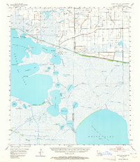
1955 Map of Grand Lake East
USGS Topo · Published 1964About this map
Maple Marsh and a vast complex of wetlands dominate this coastal Louisiana landscape, captured by planetable surveys in the mid-1950s. The map illustrates an environment defined by the transition from open water to marshy prairie, where the Intracoastal Waterway cuts a straight path through the natural meanders of Latanier Bayou and Blackfish Bayou. The economy of the era is clearly visible through the numerous energy sites, including the Grand Lake Oil and Gas Field and Pecan Lake Gas Field, alongside traditional recreational outposts like the Lulu Hunting Club and Stanolind Club. Notable terrain features include named islands like Rabbit Island and Deer Island that emerge from the shallow expanses of Grand Lake and White Lake. Of particular interest to local historians is the Pirogue Trail, which traces a traditional water route through the southern marshes.
Find a feature on this map
54 named features on this map. Tap any name to fly to it.
Don’t see what you’re looking for? This feature index may not catch every label — zoom into the map to look around manually.
Map Details
Editions of this 1955 Grand Lake East Map
3 editions found
Other maps of this area

1932 · Constance Bayou NE
USGS Topo · 1:31,680

1932 · Constance Bayou NW
USGS Topo · 1:31,680

1934 · Catfish Lake
USGS Topo · 1:24,000

1934 · Latania Lake
USGS Topo · 1:24,000

1935 · Catfish Lake
USGS Topo · 1:31,680

1935 · Latania Lake
USGS Topo · 1:31,680

1945 · Pecan Island NW
USGS Topo · 1:31,680

1946 · Morse
USGS Topo · 1:31,680

1946 · Hog Bayou NE
USGS Topo · 1:31,680

1946 · Lake Arthur
USGS Topo · 1:31,680