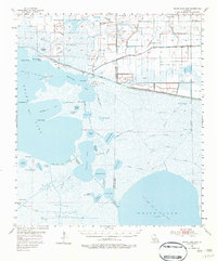
1955 Map of Grand Lake East
USGS Topo · Published 1983About this map
Maple Marsh dominates this mid-century landscape of the Gulf Coast, where the transition between land and sea is defined by intricate wetlands and active extraction. The 1950s economy is clearly visible through several expansive petroleum zones, including the Grand Lake Oil and Gas Field and the West White Lake Oil and Gas Field. A fascinating cultural layer appears in the form of traditional water routes, such as the Le Bleu Pirogue Trail and the Gang Pirogue Trail, which weave through the marshlands and connect isolated water bodies like Alligator Lake and Blackfish Lake. The presence of several sportsman's outposts, such as the Lulu Hunting Club and Stanglind Club, underscores the area's reputation for coastal hunting and fishing, while the Gueydan Cem provides a focal point for local genealogical interest near the northern levee system.
Find a feature on this map
71 named features on this map. Tap any name to fly to it.
Don’t see what you’re looking for? This feature index may not catch every label — zoom into the map to look around manually.
Map Details
Editions of this 1955 Grand Lake East Map
3 editions found
Other maps of this area

1932 · Constance Bayou NE
USGS Topo · 1:31,680

1932 · Constance Bayou NW
USGS Topo · 1:31,680

1934 · Catfish Lake
USGS Topo · 1:24,000

1934 · Latania Lake
USGS Topo · 1:24,000

1935 · Catfish Lake
USGS Topo · 1:31,680

1935 · Latania Lake
USGS Topo · 1:31,680

1945 · Pecan Island NW
USGS Topo · 1:31,680

1946 · Morse
USGS Topo · 1:31,680

1946 · Hog Bayou NE
USGS Topo · 1:31,680

1946 · Lake Arthur
USGS Topo · 1:31,680