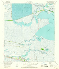
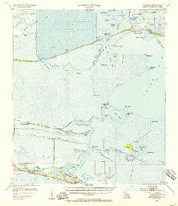
1955 Map of Grand Lake West
USGS Topo · Published 1960About this map
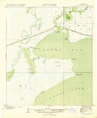
Lacassine National Wildlife Refuge dominates the northern reaches of this coastal Louisiana landscape, where the Intracoastal Waterway cuts through an intricate network of marshes and open water. The map reveals the unique geography of the chenier plain, where ridges like Hackberry Ridge and Pumpkin Ridge provide the only elevated ground for human settlement. Along these narrow strips of oak-covered land, the community of Grand Cheniere stretches parallel to the Mermentau River, supported by the Grand Cheniere Gas Field.
Find a feature on this map
66 named features on this map. Tap any name to fly to it.
Don’t see what you’re looking for? This feature index may not catch every label — zoom into the map to look around manually.
Map Details
Editions of this 1955 Grand Lake West Map
3 editions found

Other maps of this area

1932 · Lake Charles SE
USGS Topo · 1:31,680

1932 · Constance Bayou NW
USGS Topo · 1:31,680
1934 · Catfish Lake
USGS Topo · 1:24,000
1934 · Lake Misere
USGS Topo · 1:24,000

1934 · Boudreaux Lake
USGS Topo · 1:24,000

1934 · Latania Lake
USGS Topo · 1:24,000

1935 · Lake Misere
USGS Topo · 1:31,680

1935 · Catfish Lake
USGS Topo · 1:31,680
1935 · Latania Lake
USGS Topo · 1:31,680

1935 · Boudreaux Lake
USGS Topo · 1:31,680