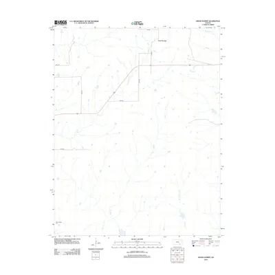
2012 Map of Grand Summit
USGS Topo · Published 2012About this map
Grand Summit anchors this portion of eastern Cowley County, representing a pocket of the Kansas Flint Hills defined by a complex network of prairie drainage. The landscape is carved by numerous seasonal and perennial waterways, including the long reaches of Otter Cr and Union Cr that flow southward through the cattle-grazing country. A legacy of early settlement is preserved at Gospel Ridge Cem in the southwestern corner, a site that serves as a primary point of interest for genealogists tracing pioneer families in the township. The infrastructure is characterized by a strict section-line road grid, with routes like 72nd Rd and 333rd Rd providing access to the high ground between Cedar Cr and Schrader Br. This survey captures the rural character of the region before further modern developments altered the traditional ranching landscape.
Find a feature on this map
14 named features on this map. Tap any name to fly to it.
Don’t see what you’re looking for? This feature index may not catch every label — zoom into the map to look around manually.
Map Details
Editions of this 2012 Grand Summit Map
This is the sole edition of this map. No revisions or reprints were ever made.
Other maps of this area

1885 · Sedan
USGS Topo · 1:125,000

1889 · Burden
USGS Topo · 1:125,000

1889 · Sedan
USGS Topo · 1:125,000

1955 · Wichita
USGS Topo · 1:250,000

1958 · Wichita
USGS Topo · 1:250,000

1962 · Grand Summit
USGS Topo · 1:24,000

1962 · Dexter
USGS Topo · 1:24,000
1962 · Cloverdale
USGS Topo · 1:24,000
1962 · Dexter NE
USGS Topo · 1:24,000
1962 · Grenola
USGS Topo · 1:24,000