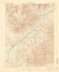
1929 Map of Grand Valley
USGS Topo · Published 1929About this map
The Colorado River carves a deep path through the Western Slope in the late 1920s, serving as the primary corridor for the Denver and Rio Grande Western railroad. This industrial and agricultural lifeline connects the town of Grand Valley in the northeast to De Beque in the southwest, passing small sidings and stops like Una and Kobe. The landscape is defined by extreme verticality, with the Book Plateau rising to the north and the heavily timbered Grand Mesa National Forest dominating the southern reaches.
Find a feature on this map
62 named features on this map. Tap any name to fly to it.
Don’t see what you’re looking for? This feature index may not catch every label — zoom into the map to look around manually.
Map Details
Editions of this 1929 Grand Valley Map
3 editions found
Other maps of this area

1906 · Grand Hogback
USGS Topo · 1:125,000

1910 · Grand Hogback
USGS Topo · 1:125,000

1925 · Parachute Creek
USGS Topo · 1:62,500

1927 · Parachute Creek
USGS Topo · 1:62,500

1929 · Grand Valley
USGS Topo · 1:62,500

1929 · Highmore
USGS Topo · 1:62,500

1929 · Roan Creek
USGS Topo · 1:62,500

1952 · Anvil Points
USGS Topo · 1:24,000

1955 · Collbran
USGS Topo · 1:24,000

1955 · Cameo
USGS Topo · 1:24,000