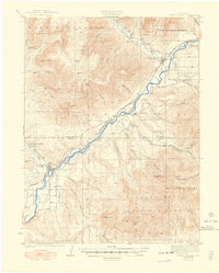
1929 Map of Grand Valley
USGS Topo · Published 1948About this map
The Colorado River corridor defines this industrial and agricultural landscape as it appeared in the late 1920s, dominated by the early development of the Naval Oil Shale Reserve. The topography transitions sharply from the high Roan Plateau in the north to the formidable heights of Battlement Mesa and the Grand Mesa National Forest in the south. Along the river valley, the Denver and Rio Grande railroad provides the primary transit link between the town of De Beque and Grand Valley. Local life is anchored by family-named landmarks like Cunningham Ranch and Connell Cabin, alongside essential community outposts such as Crawford Sch and Battlement Sch. The map records an era when extraction was transforming the high desert, evidenced by the American Shale Camp and another Shale Camp situated near Horse Mtn.
Find a feature on this map
67 named features on this map. Tap any name to fly to it.
Don’t see what you’re looking for? This feature index may not catch every label — zoom into the map to look around manually.
Map Details
Editions of this 1929 Grand Valley Map
3 editions found
Other maps of this area

1906 · Grand Hogback
USGS Topo · 1:125,000

1910 · Grand Hogback
USGS Topo · 1:125,000

1925 · Parachute Creek
USGS Topo · 1:62,500

1927 · Parachute Creek
USGS Topo · 1:62,500

1929 · Grand Valley
USGS Topo · 1:62,500

1929 · Highmore
USGS Topo · 1:62,500

1929 · Roan Creek
USGS Topo · 1:62,500

1952 · Anvil Points
USGS Topo · 1:24,000

1955 · Collbran
USGS Topo · 1:24,000

1955 · Cameo
USGS Topo · 1:24,000