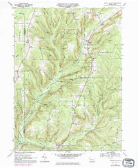
1968 Map of Grand Valley
USGS Topo · Published 1974About this map
Pennsylvania's northwestern oil fields dominate this landscape along the border of Crawford and Warren Counties. The extensive presence of Oil Wells and broad Oil Field designations throughout townships like Rome, Eldred, and Southwest reveals an economy deeply tied to petroleum extraction. This 1960s survey illustrates a rural industrial network where active drilling sites and compressor stations sit alongside small settlements such as Grand Valley and Enterprise.
Find a feature on this map
36 named features on this map. Tap any name to fly to it.
Don’t see what you’re looking for? This feature index may not catch every label — zoom into the map to look around manually.
Map Details
Editions of this 1968 Grand Valley Map
3 editions found
Other maps of this area

1926 · Youngsville
USGS Topo · 1:62,500

1927 · Tidioute
USGS Topo · 1:48,000

1927 · Titusville
USGS Topo · 1:62,500

1929 · Corry
USGS Topo · 1:48,000

1929 · Youngsville
USGS Topo · 1:62,500

1930 · Tidioute
USGS Topo · 1:62,500

1932 · Corry
USGS Topo · 1:62,500

1933 · Titusville
USGS Topo · 1:62,500

1943 · Youngsville
USGS Topo · 1:62,500

1957 · Warren
USGS Topo · 1:250,000