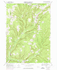
1968 Map of Grand Valley
USGS Topo · Published 1975About this map
Grand Valley and its surrounding hill country are defined by a long history of petroleum extraction, with hundreds of Oil Wells scattered across the landscape. The infrastructure of this industry is dense, featuring an extensive Pipeline network and multiple Compressor Stations concentrated near Colorado Goodwill Hill. This 1968 field-checked record shows the remnants of earlier transport, including an Old Railroad Grade that follows the winding path of Caldwell Creek.
Find a feature on this map
38 named features on this map. Tap any name to fly to it.
Don’t see what you’re looking for? This feature index may not catch every label — zoom into the map to look around manually.
Map Details
Editions of this 1968 Grand Valley Map
3 editions found
Other maps of this area

1926 · Youngsville
USGS Topo · 1:62,500

1927 · Tidioute
USGS Topo · 1:48,000

1927 · Titusville
USGS Topo · 1:62,500

1929 · Corry
USGS Topo · 1:48,000

1929 · Youngsville
USGS Topo · 1:62,500

1930 · Tidioute
USGS Topo · 1:62,500

1932 · Corry
USGS Topo · 1:62,500

1933 · Titusville
USGS Topo · 1:62,500

1943 · Youngsville
USGS Topo · 1:62,500

1957 · Warren
USGS Topo · 1:250,000