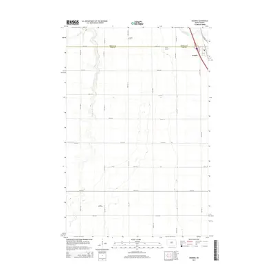
2014 Map of Grandin
USGS Topo · Published 2014About this map
Grandin sits at the intersection of the Red River Valley’s agricultural landscape and modern transportation corridors along the Traill Co Cass Co line. This 2014 survey captures the community as it functions as a local hub, with Highway 81 SE and the railroad cutting through the town's eastern edge. The surrounding terrain is defined by the gentle meandering of the Elm River and the S Br Elm River, which carve subtle drainage patterns through the strictly gridded section lines. For local historians and genealogists, the map identifies key community sites such as the Grandin Cem located just north of the county line and the Rose Valley Cem to the southwest. The presence of the Dakota Airport northwest of town highlights the specialized infrastructure supporting the region's expansive farming operations.
Find a feature on this map
23 named features on this map. Tap any name to fly to it.
Don’t see what you’re looking for? This feature index may not catch every label — zoom into the map to look around manually.
Map Details
Editions of this 2014 Grandin Map
This is the sole edition of this map. No revisions or reprints were ever made.
Other maps of this area

1918 · Kelso
USGS Topo · 1:62,500

1918 · Hendrum
USGS Topo · 1:62,500

1943 · Kelso
USGS Topo · 1:62,500

1952 · Grand Forks
USGS Topo · 1:250,000

1956 · Grand Forks
USGS Topo · 1:250,000
1963 · Argusville
USGS Topo · 1:24,000

1963 · Gardner
USGS Topo · 1:24,000

1963 · Kelso
USGS Topo · 1:24,000

1963 · Halstad SW
USGS Topo · 1:24,000

1966 · Grand Forks
USGS Topo · 1:250,000