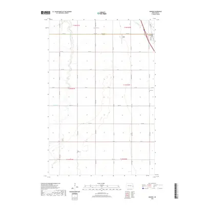
2020 Map of Grandin
USGS Topo · Published 2020About this map
Grandin sits at the northeastern edge of this Red River Valley landscape, positioned where the border between Traill Co and Cass Co meets the winding course of the Elm River. The town's grid is bounded by Co Hwy 81 and Brown Ave, serving as a focal point for the surrounding agricultural sections. Moving south and west, the terrain is defined by the meandering S Br Elm River and a strictly organized network of section-line roads like 160th Ave SE and 17th St SE. For local historians and genealogists, the map identifies several significant burial sites across the townships, including Grandin Cem near the county line, Golliet Cem to the southeast, and Rose Valley Cem located further south along 161st Ave SE. The presence of the Dakota Airport northwest of the main settlement highlights the area's continued connection to regional transport.
Find a feature on this map
34 named features on this map. Tap any name to fly to it.
Don’t see what you’re looking for? This feature index may not catch every label — zoom into the map to look around manually.
Map Details
Editions of this 2020 Grandin Map
This is the sole edition of this map. No revisions or reprints were ever made.
Other maps of this area

1918 · Kelso
USGS Topo · 1:62,500

1918 · Hendrum
USGS Topo · 1:62,500

1943 · Kelso
USGS Topo · 1:62,500

1952 · Grand Forks
USGS Topo · 1:250,000

1956 · Grand Forks
USGS Topo · 1:250,000
1963 · Argusville
USGS Topo · 1:24,000

1963 · Gardner
USGS Topo · 1:24,000

1963 · Kelso
USGS Topo · 1:24,000

1963 · Halstad SW
USGS Topo · 1:24,000

1966 · Grand Forks
USGS Topo · 1:250,000