
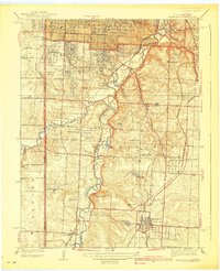
1939 Map of Grandview
USGS Topo · Published 1939About this map
The Blue River carves a winding valley through the heart of this landscape, separating the developing suburban fringes of southern Kansas City from the more open tracts of Washington township. Along its banks, the intersection of nature and infrastructure is evident, where the St Louis-San Francisco Railway and several country clubs, including Oakwood Golf Club and Chevy Chase Golf Club, take advantage of the topography. This 1930s survey captures a transition period as early settlements like Hickman Mills and Grandview anchor a network of rural roads that would soon become major arterial corridors.
Find a feature on this map
49 named features on this map. Tap any name to fly to it.
Don’t see what you’re looking for? This feature index may not catch every label — zoom into the map to look around manually.
Map Details
Editions of this 1939 Grandview Map
2 editions found
Other maps of this area

1887 · Harrisonville
USGS Topo · 1:125,000

1887 · Olathe
USGS Topo · 1:125,000

1890 · Kansas City
USGS Topo · 1:125,000

1892 · Harrisonville
USGS Topo · 1:125,000

1893 · Olathe
USGS Topo · 1:125,000

1894 · Kansas City
USGS Topo · 1:125,000

1894 · Harrisonville
USGS Topo · 1:125,000

1894 · Independence
USGS Topo · 1:125,000

1934 · Independence
USGS Topo · 1:24,000

1934 · Grandview
USGS Topo · 1:24,000