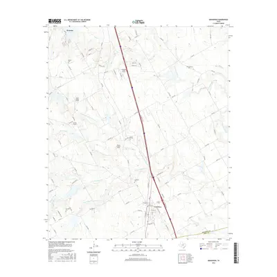
2016 Map of Grandview
USGS Topo · Published 2016About this map
The town of Grandview serves as a central hub in Johnson County, defined by a network of drainage systems that feed into the Chambers Creek watershed. Interstate 35W bisects the landscape, running past rural infrastructure such as Luscombe Acres Airport and Flying M Ranch Airport. This 2016 survey illustrates the persistent agricultural and residential character of the region, where numerous family and community burial grounds, including Old Hill Cem, Antioch Rest Cem, and Boatright Cem, remain as significant markers of local heritage. The complex hydrography is dominated by the many branches of Chambers Creek, such as Middle Fork S Fork Chambers Cr and N Fork Chambers Cr, which dictate the local road patterns. These waterways and the surrounding county roads provide a detailed view of the rural homesteads and ranching properties that define the area between Grandview and the southern outskirts of Alvarado.
Find a feature on this map
92 named features on this map. Tap any name to fly to it.
Don’t see what you’re looking for? This feature index may not catch every label — zoom into the map to look around manually.
Map Details
Editions of this 2016 Grandview Map
This is the sole edition of this map. No revisions or reprints were ever made.
Other maps of this area

1891 · Cleburne
USGS Topo · 1:125,000

1894 · Cleburne
USGS Topo · 1:125,000

1927 · Blum
USGS Topo · 1:62,500

1954 · Dallas
USGS Topo · 1:250,000

1958 · Dallas
USGS Topo · 1:250,000

1960 · Keene
USGS Topo · 1:24,000

1960 · Cleburne East
USGS Topo · 1:24,000
1961 · Maypearl
USGS Topo · 1:24,000

1961 · Alvarado
USGS Topo · 1:24,000
1961 · Venus
USGS Topo · 1:24,000