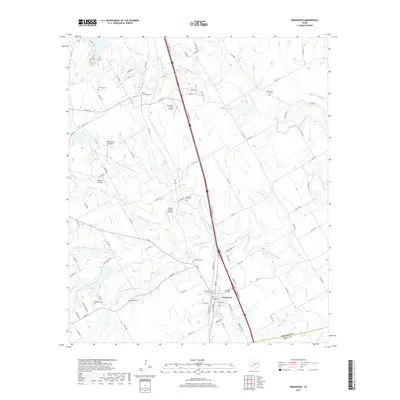
2019 Map of Grandview
USGS Topo · Published 2019About this map
Grandview serves as the primary hub of this North Texas landscape, situated along the dividing line of the Johnson and Hill county border. This 2019 survey documents a rural environment where agricultural land is segmented by an extensive network of creeks, including the S Fork Chambers Creek and its many tributaries. The area is notable for its high density of family and community burial grounds, such as the Old Hill, Antioch Rest, and Boatright cemeteries, which offer significant value for genealogical research. The presence of several small private airstrips, including Flying M Ranch Airport and Luscombe Acres Airport, suggests a region where private aviation integrates with large ranching and farming operations. The map details the transition from town streets to a complex system of farm-to-market and county roads that define the local transport patterns.
Find a feature on this map
89 named features on this map. Tap any name to fly to it.
Don’t see what you’re looking for? This feature index may not catch every label — zoom into the map to look around manually.
Map Details
Editions of this 2019 Grandview Map
This is the sole edition of this map. No revisions or reprints were ever made.
Other maps of this area

1891 · Cleburne
USGS Topo · 1:125,000

1894 · Cleburne
USGS Topo · 1:125,000

1927 · Blum
USGS Topo · 1:62,500

1954 · Dallas
USGS Topo · 1:250,000

1958 · Dallas
USGS Topo · 1:250,000

1960 · Keene
USGS Topo · 1:24,000

1960 · Cleburne East
USGS Topo · 1:24,000
1961 · Maypearl
USGS Topo · 1:24,000

1961 · Alvarado
USGS Topo · 1:24,000
1961 · Venus
USGS Topo · 1:24,000