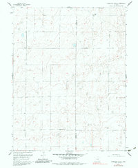
1959 Map of Grandview School
USGS Topo · Published 1983About this map
The High Plains along the border of Pueblo and Crowley counties appear as a sparsely settled expanse of terrain in this 1959 survey. The landscape is defined by its subtle contours and remote character, with the Grandview Sch serving as a primary landmark for the local community. The mapping reflects a period when this part of the Colorado plains relied on a network of unimproved roads and light-duty paths to connect isolated homesteads and ranching operations. One such notable property is the Schubert Ranch, located in the northeastern portion of the sheet. The lack of major urban development or industrial infrastructure emphasizes the agricultural and rural endurance of this region, providing a clear record of land use and property boundaries before more modern shifts in the high desert landscape occurred.
Find a feature on this map
3 named features on this map. Tap any name to fly to it.
Don’t see what you’re looking for? This feature index may not catch every label — zoom into the map to look around manually.
Map Details
Editions of this 1959 Grandview School Map
3 editions found
Other maps of this area

1889 · Sanborn
USGS Topo · 1:125,000

1891 · Sanborn
USGS Topo · 1:125,000

1891 · Catlin
USGS Topo · 1:125,000

1891 · Nepesta
USGS Topo · 1:125,000

1893 · Nepesta
USGS Topo · 1:125,000

1893 · Sanborn
USGS Topo · 1:125,000

1893 · Big Springs
USGS Topo · 1:125,000

1893 · Catlin
USGS Topo · 1:125,000

1904 · Nepesta
USGS Topo · 1:125,000

1954 · Lamar
USGS Topo · 1:250,000