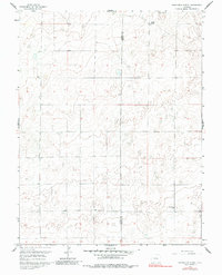
1959 Map of Grandview School
USGS Topo · Published 1988About this map
Pueblo Co and Crowley Co meet along a sparse, rolling prairie landscape captured in this mid-century topographic survey. The area is defined by its expansive agricultural character and the limited number of permanent structures typical of the high plains during this era. A focal point for the local rural community is the Grandview Sch in the southeastern quadrant, which served as a central landmark for ranching families in the vicinity. To the north, the Schubert Ranch stands as one of the few named homesteads in the region, illustrating the large-scale landholdings that characterized this portion of Colorado. The map reveals the intricate network of unimproved roads and light-duty paths that connected these isolated outposts, providing a clear view of the rural infrastructure before significant modern development altered the drainage and culture of the plains.
Find a feature on this map
3 named features on this map. Tap any name to fly to it.
Don’t see what you’re looking for? This feature index may not catch every label — zoom into the map to look around manually.
Map Details
Editions of this 1959 Grandview School Map
3 editions found
Other maps of this area

1889 · Sanborn
USGS Topo · 1:125,000

1891 · Sanborn
USGS Topo · 1:125,000

1891 · Catlin
USGS Topo · 1:125,000

1891 · Nepesta
USGS Topo · 1:125,000

1893 · Nepesta
USGS Topo · 1:125,000

1893 · Sanborn
USGS Topo · 1:125,000

1893 · Big Springs
USGS Topo · 1:125,000

1893 · Catlin
USGS Topo · 1:125,000

1904 · Nepesta
USGS Topo · 1:125,000

1954 · Lamar
USGS Topo · 1:250,000