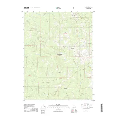
2022 Map of Granite Chief
USGS Topo · Published 2022About this map
Granite Chief and the high Sierra Nevada crest dominate this part of the Tahoe National Forest in Placer County. The terrain is defined by a dense network of backcountry routes, including the Pacific Crest National Scenic Trail and the Western States Trail, which weave through glacial valleys and over high ridges like the Forest Hill Divide. The map illustrates the headwaters of the North Fork American River and the Middle Fork American River, separated by massive landmarks such as Lyon Peak and Needle Peak.
Find a feature on this map
61 named features on this map. Tap any name to fly to it.
Don’t see what you’re looking for? This feature index may not catch every label — zoom into the map to look around manually.
Map Details
Editions of this 2022 Granite Chief Map
This is the sole edition of this map. No revisions or reprints were ever made.
Other maps of this area

1891 · Truckee
USGS Topo · 1:125,000

1893 · Truckee
USGS Topo · 1:125,000

1895 · Truckee
USGS Topo · 1:125,000

1932 · Truckee
USGS Topo · 1:96,000

1940 · Truckee
USGS Topo · 1:125,000

1953 · Granite Chief
USGS Topo · 1:24,000
1953 · Royal Gorge
USGS Topo · 1:24,000
1953 · Wentworth Springs
USGS Topo · 1:24,000
1953 · Bunker Hill
USGS Topo · 1:24,000

1953 · Granite Chief
USGS Topo · 1:62,500