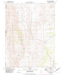
1980 Map of Granite Peak
USGS Topo · Published 1981About this map
Petersen Mountain and the Sand Hills dominate this high-desert terrain on the border of California and Nevada during the late 1970s. The landscape is defined by its vital water sources, with numerous named springs such as Chokecherry Spring and Tunnel Spring serving as critical landmarks for ranchers and travelers in this arid environment. The presence of several Prospects scattered across the slopes suggests a history of mineral exploration typical of the Washoe Co backcountry. Settlement is minimal, focused instead on the utility of the land, as seen at Pasture Well and the network of routes like Red Rock Road and various Jeep Trails that traverse Red Rock Valley. The map records a moment of transition for this remote corner of Nevada, where the rugged topography around Granite Peak remains largely untouched except for these small-scale industrial and agricultural markers.
Find a feature on this map
27 named features on this map. Tap any name to fly to it.
Don’t see what you’re looking for? This feature index may not catch every label — zoom into the map to look around manually.
Map Details
Editions of this 1980 Granite Peak Map
2 editions found
Other maps of this area

1890 · Sierraville
USGS Topo · 1:125,000

1891 · Reno
USGS Topo · 1:125,000

1892 · Sierraville
USGS Topo · 1:125,000

1893 · Reno
USGS Topo · 1:125,000

1894 · Sierraville
USGS Topo · 1:125,000

1950 · Chilcoot
USGS Topo · 1:62,500

1950 · Reno
USGS Topo · 1:62,500

1951 · Reno
USGS Topo · 1:62,500

1955 · Loyalton
USGS Topo · 1:62,500

1957 · Dogskin Mountain
USGS Topo · 1:62,500