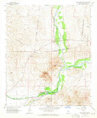
1964 Map of Granite Reef Dam
USGS Topo · Published 1965About this map
Granite Reef Dam serves as the critical hydrological hub where the Verde River meets the Salt River, directing water into the massive Arizona Canal and Southern Canal systems. This mid-1960s survey captures the landscape as it transitions from the high desert peaks of Apache Peak and Mount McDowell to the engineered riparian corridors of the Phoenix valley periphery. The map details the intersection of the Fort Mc Dowell Indian Reservation and the Tonto National Forest, showing a network of Jeep Trails and ranching infrastructure like the P Bar Ranch. Cultural landmarks such as the Jim Hart Memorial Monument and Camp Reno Historical Marker are noted alongside early recreation sites, including the Phon D Sutton Recreation Area and Coon Bluff Forest Camp.
Find a feature on this map
36 named features on this map. Tap any name to fly to it.
Don’t see what you’re looking for? This feature index may not catch every label — zoom into the map to look around manually.
Map Details
Editions of this 1964 Granite Reef Dam Map
3 editions found
Other maps of this area

1904 · Camelback
USGS Topo · 1:62,500

1904 · Desert Well
USGS Topo · 1:62,500

1904 · Ft. McDowell
USGS Topo · 1:62,500

1906 · Camelsback
USGS Topo · 1:62,500

1906 · Ft. McDowell
USGS Topo · 1:62,500

1906 · Desert Well
USGS Topo · 1:62,500

1913 · Mesa
USGS Topo · 1:62,500

1915 · Mesa
USGS Topo · 1:62,500

1930 · Cave Creek
USGS Topo · 1:125,000

1939 · Cave Creek
USGS Topo · 1:125,000