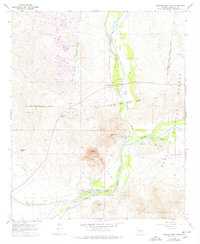
1964 Map of Granite Reef Dam
USGS Topo · Published 1977About this map
The confluence of the Verde River and the Salt River serves as the central focal point of this arid landscape on the edge of the Tonto National Forest. Water infrastructure is critical to the region's character, as evidenced by the Arizona Canal, the South Canal, and a prominent Aqueduct system designed to move water through the desert heat. Historic landmarks like the Camp Reno Historical Marker and the Jim Hart Memorial Monument mark the presence of early settlers and frontier history, while the complex borders of the Fort Mc Dowell Indian Reservation Boundary and Salt River Indian Reservation Boundary intersect at the riverbanks. Rising sharply from the valley floor, landmarks such as Mount McDowell and Apache Peak provide a dramatic contrast to the active recreation sites at Coon Bluff Forest Camp and the Phon D Sutton Recreation Area.
Find a feature on this map
30 named features on this map. Tap any name to fly to it.
Don’t see what you’re looking for? This feature index may not catch every label — zoom into the map to look around manually.
Map Details
Editions of this 1964 Granite Reef Dam Map
3 editions found
Other maps of this area

1904 · Camelback
USGS Topo · 1:62,500

1904 · Desert Well
USGS Topo · 1:62,500

1904 · Ft. McDowell
USGS Topo · 1:62,500

1906 · Camelsback
USGS Topo · 1:62,500

1906 · Ft. McDowell
USGS Topo · 1:62,500

1906 · Desert Well
USGS Topo · 1:62,500

1913 · Mesa
USGS Topo · 1:62,500

1915 · Mesa
USGS Topo · 1:62,500

1930 · Cave Creek
USGS Topo · 1:125,000

1939 · Cave Creek
USGS Topo · 1:125,000