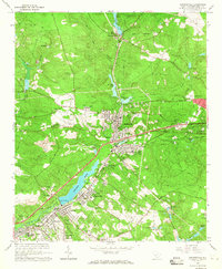
1964 Map of Graniteville
USGS Topo · Published 1965About this map
Industrial and textile history define this mid-1960s landscape, where the Southern Railway and a dedicated Trolley Line trace the path of commerce through the Horse Creek Valley. The town of Graniteville serves as a central hub, surrounded by smaller company settlements like Vaucluse, Warrenville, and Gloverville. Significant water features such as Langley Pond and Vaucluse Pond were essential to the region's development, providing the power and resources for the local mill economy.
Find a feature on this map
81 named features on this map. Tap any name to fly to it.
Don’t see what you’re looking for? This feature index may not catch every label — zoom into the map to look around manually.
Map Details
Editions of this 1964 Graniteville Map
3 editions found
Other maps of this area

1920 · Aiken
USGS Topo · 1:48,000

1920 · Talatha
USGS Topo · 1:48,000

1921 · Augusta
USGS Topo · 1:62,500

1921 · Aiken
USGS Topo · 1:62,500

1921 · Talatha
USGS Topo · 1:62,500

1923 · Warrenville
USGS Topo · 1:48,000

1928 · Warrenville
USGS Topo · 1:62,500

1943 · Aiken
USGS Topo · 1:62,500

1943 · Augusta East
USGS Topo · 1:125,000

1943 · Warrenville
USGS Topo · 1:62,500