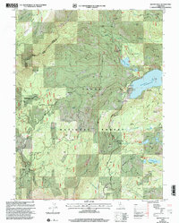
2000 Map of Graniteville
USGS Topo · Published 2003About this map
Gold mining history is etched across the landscape of Tahoe National Forest, where the settlement of Graniteville sits amidst a high concentration of historic workings. At the turn of the 21st century, the area remained a complex map of industrial heritage and water management, dominated by the Bowman Lake reservoir and the surrounding high-country terrain. Numerous mining sites such as the Birchville Mine, Spotswood Mine, and the Hotwater Mine define the ridges, while legacy locations like the Marsh Mill and Old Condon Mill indicate the scale of former processing operations. The topography is split by the Middle Yuba River and Poorman Creek, revealing a network of ridges and flats including Pat Yore Flat and Murphy Flat. This map also documents vital water infrastructure, with several Gaging Stations situated along the steep descent of Bowman Canyon.
Find a feature on this map
57 named features on this map. Tap any name to fly to it.
Don’t see what you’re looking for? This feature index may not catch every label — zoom into the map to look around manually.
Map Details
Editions of this 2000 Graniteville Map
This is the sole edition of this map. No revisions or reprints were ever made.
Other maps of this area

1891 · Downieville
USGS Topo · 1:125,000

1891 · Colfax
USGS Topo · 1:125,000

1892 · Colfax
USGS Topo · 1:125,000

1893 · Downieville
USGS Topo · 1:125,000

1894 · Colfax
USGS Topo · 1:125,000

1895 · Downieville
USGS Topo · 1:125,000

1896 · Downieville
USGS Topo · 1:125,000

1897 · Downieville
USGS Topo · 1:125,000

1898 · Colfax
USGS Topo · 1:125,000

1900 · Colfax
USGS Topo · 1:125,000