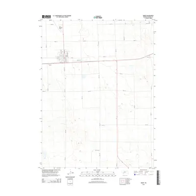
2014 Map of Grant
USGS Topo · Published 2014About this map
The town of Grant serves as the central hub for this high plains landscape in Perkins County. As seen in the mid-2010s, the community layout follows a traditional grid centered on thoroughfares such as Central Ave and W 4th St. Located just west of the main settlement is Fairview Cem, a key landmark for genealogical research in the area. North of the town center, the Grant Municipal Airport reflects the importance of aviation infrastructure for this rural region. The surrounding terrain is defined by an extensive network of section-line roads, including Road 760 and Road 331, which facilitate the local agricultural economy and link the isolated farmsteads across the undulating prairie.
Find a feature on this map
30 named features on this map. Tap any name to fly to it.
Don’t see what you’re looking for? This feature index may not catch every label — zoom into the map to look around manually.
Map Details
Editions of this 2014 Grant Map
This is the sole edition of this map. No revisions or reprints were ever made.
Other maps of this area

1954 · McCook
USGS Topo · 1:250,000

1957 · McCook
USGS Topo · 1:250,000

1958 · McCook
USGS Topo · 1:250,000

1961 · Brandon NE
USGS Topo · 1:24,000

1961 · Lamar NE
USGS Topo · 1:24,000

1961 · Brandon SE
USGS Topo · 1:24,000
1973 · Grant NE
USGS Topo · 1:24,000

1973 · Imperial NE
USGS Topo · 1:24,000
1973 · Grant
USGS Topo · 1:24,000
1973 · Imperial NW
USGS Topo · 1:24,000