
1961 Map of Brandon SE
USGS Topo · Published 1963About this map
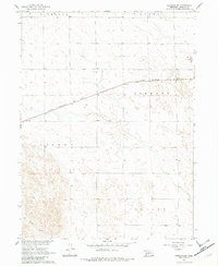
The Chicago Burlington and Quincy railroad cuts a straight diagonal through this high plains landscape, serving as the primary industrial artery for the region during the early 1960s. Surveyed as part of the Missouri River Basin development program, the map reveals a sparsely settled agricultural area divided between the townships of Liberty and Lisbon. Local education is anchored by School No 50, a solitary landmark in an area characterized by section lines and fence boundaries. The terrain transitions from the elevated Highland north of the tracks down toward the southern Valley, where Spring Creek meanders through the corner of the quadrangle. A small Gravel Pit near the eastern border provides a glimpse into the local materials used for road building and maintenance in this Perkins County expanse.
Find a feature on this map
8 named features on this map. Tap any name to fly to it.
Don’t see what you’re looking for? This feature index may not catch every label — zoom into the map to look around manually.
Map Details
Editions of this 1961 Brandon SE Map
2 editions found
Other maps of this area

1954 · McCook
USGS Topo · 1:250,000

1957 · McCook
USGS Topo · 1:250,000

1958 · McCook
USGS Topo · 1:250,000

1961 · Brandon NE
USGS Topo · 1:24,000

1961 · Lamar NE
USGS Topo · 1:24,000

1961 · Brandon NW
USGS Topo · 1:24,000

1961 · Lamar NW
USGS Topo · 1:24,000

1961 · Brandon
USGS Topo · 1:24,000
1973 · Grant
USGS Topo · 1:24,000
1973 · Imperial NW
USGS Topo · 1:24,000