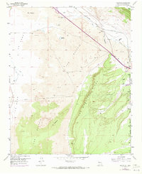
1957 Map of Grants SE
USGS Topo · Published 1973About this map
The Malpais dominates this corner of New Mexico, where ancient lava flows create a stark, basaltic plain known locally as Lava and La Vega. The landscape is a study in geological contrast, as the dark volcanic fields of El Medano meet the rising sandstone heights of Las Ventanas Ridge and the flat-topped Horace Mesa. This 1950s survey captures the region just before significant interstate development, showing the Atchison Topeka and Santa Fe railroad following the path of the Rio San Jose through the northern corridor. In the southeastern portion, the Acoma Pueblo Indian Reservation boundary is clearly delineated, marking ancestral lands against the surrounding terrain. Vital water sources like Rancho del Padre Spring and Laguna del Chical appear as essential landmarks for navigation and survival in this arid environment.
Find a feature on this map
19 named features on this map. Tap any name to fly to it.
Don’t see what you’re looking for? This feature index may not catch every label — zoom into the map to look around manually.
Map Details
Editions of this 1957 Grants SE Map
Other maps of this area

1883 · Mt. Taylor
USGS Topo · 1:250,000

1886 · Mt. Taylor
USGS Topo · 1:250,000

1892 · Mt. Taylor
USGS Topo · 1:250,000

1899 · Mt. Taylor
USGS Topo · 1:250,000

1917 · Broom Mountain
USGS Topo · 1:125,000

1954 · Socorro
USGS Topo · 1:250,000

1957 · San Rafael
USGS Topo · 1:24,000

1957 · Lobo Springs
USGS Topo · 1:24,000

1957 · Grants SE
USGS Topo · 1:24,000

1957 · Mc Cartys
USGS Topo · 1:24,000