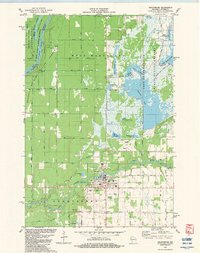
1982 Map of Grantsburg
USGS Topo · Published 1983About this map
Grantsburg serves as the focal point of this northern Wisconsin landscape, situated along the Wood River just east of the St Croix River boundary with Minnesota. The geography is defined by extensive managed wetlands and water control systems, most notably within the Crex Meadows State Wildlife Refuge. This area features a complex network of artificial flowages, including South Refuge Flowage and Dike 6 Flowage, which surround Phantom Lake. These features reveal a landscape heavily modified for conservation and hunting, contrasted by the protected riparian corridor of the St Croix National Scenic Riverway. In the southern portion of the village, local civic life is represented by the County Fairground, the Municipal Airport, and several local cemeteries. Rural roads such as Bloom Road and Pete Nelson Road provide access to the surrounding timberlands of the Governor Knowles State Forest.
Find a feature on this map
54 named features on this map. Tap any name to fly to it.
Don’t see what you’re looking for? This feature index may not catch every label — zoom into the map to look around manually.
Map Details
Editions of this 1982 Grantsburg Map
This is the sole edition of this map. No revisions or reprints were ever made.
Other maps of this area

1950 · Rush City
USGS Topo · 1:48,000

1950 · Grantsburg
USGS Topo · 1:48,000

1951 · Milltown
USGS Topo · 1:48,000

1953 · Stillwater
USGS Topo · 1:250,000

1955 · Rush City
USGS Topo · 1:62,500

1955 · Milltown
USGS Topo · 1:62,500

1955 · Stillwater
USGS Topo · 1:250,000

1958 · Stillwater
USGS Topo · 1:250,000

1961 · Pine City
USGS Topo · 1:62,500

1962 · Grantsburg
USGS Topo · 1:62,500